August 2017—Imagine living in an economically vibrant city of nearly 50,000 people. Now imagine that you don’t know where basic public services like police stations, schools and hospitals are located or even where the official city boundaries are.
Until recently, that was the case in Liberia’s Gompa City, located just south of the Guinean border. With no official map demarcating town limits or identifying where public services could be found, both city officials and residents found themselves at a disadvantage.
Citizens need accurate, up-to-date information on where they can find the public services that they rely on every day. In the case of emergencies and natural disasters, not having such information can have terrible consequences for both the city and its inhabitants. And local governments must know where private businesses are located in order to collect public revenues, which are used to fund vital public services.
The absence of such reliable information has plagued Gompa since its incorporation in 1975. With the city’s rapid growth and expansion in recent years, the need for an official map was increasingly clear and became a top priority.
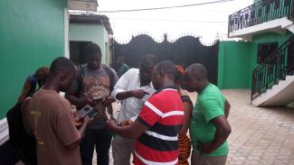
Earlier this year, USAID’s Local Empowerment for Government Inclusion and Transparency project and the Humanitarian OpenStreetMap Team began to map the city along with members of local community-based and civil society organizations. They took to the streets, armed with mobile mapping tools, to pinpoint the locations of town boundaries, local businesses, and points of service delivery, such as hospitals.
For the project team, it was especially important to include Gompa’s residents in the exercise to build the local knowledge and skills to update these maps as the city continues to grow.
“With this map … even strangers [will be able] to locate hospitals and clinics, mobile money deposits and also know where the city stops,” reports John Wonkiapeh, an employee of the Gompa City Corp.
The benefits are equally valuable for residents, who, thanks to Humanitarian OpenStreetMap’s easily accessible mobile map, can now pinpoint the locations of services such as hospitals and police stations in times of emergency.
With an official city map now in place, the USAID project and Gompa’s residents have a clear understanding of the current state of public services in the city and where improvement is needed.
USAID’s Local Empowerment for Government Inclusion and Transparency program, which runs from 2016 to 2019, assists in the transfer of authority from Liberia’s national government to counties and cities, enhances citizen participation in governance, and strengthens the skills of government officials. Project activities complement the USAID Liberia Accountability and Voice Initiative, which also works to enhance citizen engagement and government accountability throughout the country.
LINKS
Follow @USAIDLiberia, on Facebook, on Flickr, on YouTube
, “With this map … even strangers [will be able] to locate hospitals and clinics, mobile money deposits ...”

USAID
